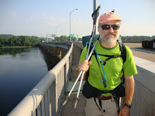
Gear
I mentioned earlier that I should talk about what we carry on our backs all day and how we are equipped. Got a little time here and battery power while we zero to do that.
Let's go over what's in the backpack. As I mentioned in the beginning, I knew I couldn't carry alot of weight. So I researched and found the outfitter at Neels Gap in Ga. Mountain Crossing: highly recommend them! They specialize in what called Ultra Light hiking. Perfect for me.
Everything low weight. Also realized about the most I can carry before I start to have all sorts of problems is about 30 lbs. Some folks out here have 60 Lbs! I don't know how they do it or why. What's in their pack? Lawn furniture?
Anyway, if you were going to be gone from home for a week and all you could take was 30 lbs, including food and water, what would you take? It adds up fast. That's the dilemma we face everytime we come to town to resupply.
So you want your basics to be as light weight as possible, starting with the pack: ours is a Catalyst- I think made in somebody's garage in Utah. Weighs just a few lbs. My tent is a one person Big Agnes Fly Creek 1, with rain cover or fly, weighs about 1-2 lbs, super tent keeps me cozy and warm in cold weather and dry as a bone in rain. Love it. Goes up super fast. Then, down sleeping bag for cold weather( sent home for now) and lightweight bag for summer. The down bag was the most expensive item , but worth it on a cold night.
Then you need some type of air mattress for camping on the hard ground. Ours is perfect, and one of the best items in our pack- don't think I could survive without it. Great nights of sleeping with. It's like a pool float- you blow it up- super fast- and it lifts you off the ground and it's insulated. Very comfy. Then my Sweety cut up a sheet for us to go under the air mattress so it wouldn't squeak, which it did in the beginning . Then you have your clothing-the actual hiking gear is synthetics- to keep you warm or cooler, depending on the weather. Shirts, pants, a winter puff jacket. Even synthetic underware! No cotton, except around camp. And rain gear- jacket and pants. And pack cover for backpack during rainstorms. We carry two small stoves: an alcohol one and a Jet Boil, which is a small gas powered boiler- very fast and light weight. All told this comes to 15 pounds. Not bad. Add in food and water and our medicine cabinet a bear bag line, water treatment and you are up to the 30 lbs. And don't forget toilet paper and a little shovel. Remember you have to carry everything!
Food: has to be non- perishable, after the first day out. So if you go for 5-6 days or 70-80 miles before resupply, it can be heavy. And water weighs about 2 lbs per liter- and we always start out with 2 liters. We usually have the tuna or chicken in a foil pouch, Knorr sides: rice or noodles. Not always satisfying. For lunch hard cheese will last for awhile, with a tortilla wrap, and of course, peanut butter! Used to have grits or instant oatmeal for breakfast, but got tired of that, now we go with cereals a dehydrated milk- good. Also real coffee with powdered cream. And lots of power bars to give you protein, cause you're burning up lots of calories out here. But overall, after a few days, you long for regular fresh foods and greens and fruit.
So a trip to town or a restaurant is the best!
Oh yeah, the bear line thing. You have all your food in a big food bag that's the heaviest item in your pack. There bears all along the AT. (I haven't seen one and hope not to.) They love our food. So, at night you can't just have your food lying around, and having it in your tent is a big "no-no", they may come and eat you too! So, the solution is to put your food up in the air. Some shelters actually have bear cables, steel cables you clip your bag to and hoist it up in the air like raising a flag. Pretty nice and simple. But if you are tenting camping on your own, you carry a nylon rope, tie one end to a small rock and throw the rock and line over a tree limb as high as you can get it. Then you attach your food bag to the rope and hoist away, high enough for the bear not to get it.
And one last important item that's indispensable for us- hiking or trekking poles. They look like ski poles, but give you great balance as you hike- almost like walking on four legs. Saved me many times from falling or slipping on
rocks. Couldn't hike far without them.
That pretty much sums it up. Later I'll talk about our daily routine.
Sent from my iPhone
Saturday, June 26, 2010
June 25 Mile 853
Zero day. Washing clothes, ate breakfast at a great diner, Weasies Kitchen. And watching World Cup. Going to outfitter for new boots. Eating and relaxing. Talking to my Sweety as much as possible. Checked our progress: Gone 39% of the trail in 40% of the total time available. Not bad. Supposedly it a little easier up ahead. Am skeptical, but we'll see.
Sent from my iPhone
June 24 Mile 853
Got up at daybreak to a cool breeze blowing briskly through our campsite. Pretty refreshing after the past few days. Ate our breakfast on the rock overlooking the valley and packed up excited about finishing this part of Va. By the time we get to Rockfish Gap at the end of the day we will have covered almost 400 miles of Va! Hiked along the top of Humpback Mtn. My outside left foot blister hurt and my right sole ached. Always something, but no knee pain even in going down. So that's an improvement. Yesterday and today for about 3-4 miles hiked right next to an old stacked stone wall that was about 4 feet high. Can't believe how much labor it took to build it! And who did it and when? Perhaps a boundry marker. Seen some before but never this long. Passed by an old chimney and stone foundation right next to the trail, on a hillside. Very odd spot for a house, we thought. Made about 8 miles by noon. We stopped for lunch by a nice stream. Took off our boots and put our feet in the water for awhile. Ahhhh! Then hiked on down the mountain, no views of course and then finally the openness of the road and the end of the Blue Ridge Parkway and across the road, the Promised Land for thru hikers-SNP -the Shennies- Shenandoah National Park. But that will wait til Saturday. Today, we go to town! So at 2:30 we had gone 13 miles and were at Rockfish Gap, a familiar place to me as I drove thru here many times during my college days at UVa just 30 miles east. Unfortunately all the motels and buildings here are abandoned. But was told a trail angel free shuttle list was avaliable. Found the list on the back of the abandoned visitors center and called the first number. Nice people, a retired minister came up and drove us down into Waynesboro to our motel.
Relaxed had a super dinner at Mings Restaurant- great place - all you can eat. And then that evening had a special treat as my big brother in my fraternity at UVa came over from Charlottesville for a visit. Super to see him.
Slept in a real bed and had electricity. Called my Sweety and had a nice long conversation. We've been out here since. March 23, less the two weeks for the wedding, basically 76 days, and I really do miss her. She'll be joining us soon for a bit, and I really am looking forward to that!
Sent from my iPhone
June 23 Mile 840
Another big hike up today. 2000 ft up over a wilderness area called Three Ridges. To start it was not too hot as we had some cool breezes. But my speed was impeded due to the new blister pain on the outside of my left heel. It pinched all day. Got a nice view high up from a place called Hanging Rock. Then, we saw lots of them, rocks that is- lot of rocks fields to hike thru. You are litteraly hiking thru a landslide- and today it seemed to go on from 2-3 miles. I felt like I was in the land of the lost. It really exhausts me to go through areas like this, as I have to slowly pick my way through. On hiker called it a "foot puzzle" and that's a good description of trying to determine where exactly to place your feet thru the endless boulder field. Later in the day, when we were very hot and thirsty we crossed a road and right in front of us to tease us or torture us, a big Heineken Beer truck drove by-no trail magic from him.
Today was also a search for water day -lucky we found some . Did not cover much ground very quickly today. We only went 13 miles by 5:30, and it was somewhat discouraging.
We were told by a south bound hiker that we would find water at a place called Dripping Rocks as we crossed the Blue Ridge Parkway. It would be our last water source for the day and then after that we had no information about camp sites, and the next shelter was many miles away, nothing we could reach before dark. We were at the base of Humpback Mtn. And had a big climb up, but hoped that near the top there might be some flat spaces for camping. So we filled up all our water sources, including our 4 liter tank and hiked up at about 6 PM. It was hot and it was up. Would we find a spot before dark?
On the way up we ran into two day hikers coming down. They had no packs and no water bottles. It was very disconcerting to see them with no gear. They were very friendly and asked where we cane from. When we said we had hiked from GA, they were wide eyed and stunned . They guy said "I want to shake your hand", normally no one shakes hands on the trail, but I did this time. Turns put they both just graduated from U. VA. Climbed up and up. Came to area with big rocks where you had to climb straight up over them. Then finally at about 7:30, came to a rock overhang with a fantastic view of the coming sunset and just beyond, to the left, the perfect camping spot. What good fortune! Put up our tents quickly and made and ate dinner watching the sunset. Actually got a cell signal here and with my little bit of remainng battery time sent a picture and text to my Sweety. Across the valley we could see the Wintergreen Sky Resort and all their condos. Actually skied there once. But our free view was superior. The sunset was magnificent and the air cool, with few bugs.
This is why you hike the AT- great moments such as this you can't get anywhere else.
Sent from my iPhone
June 22 Mile 824
Starting today I get to sleep an extra minute each morning-summer has begun, and the days will begin to get shorter. When you live by the sun, each minute counts, particulaly in the evening. Great water at the shelter. Some of the best tasting so far. Always treat it, but the creek and spring water is very good. Had a great hiking day. After 3 miles of up, got to a big piece of granite called Spy Rock. Great 360 view. Took off out packs and floated up to the top, climbing over big rock outcroppings. Beautiful views of Va. The trail in Va does not afford us too many views, so this one is in the top group.
Hiked on til lunch and ate at a pretty overlook. Cisco gave me a scare today. I always hike looking down, watching for rocks and roots that trip me up. He was up the trail a bit and stopped. I didn't see him til all of a sudden he said "watch out"! I glanced ahead and saw fur. It made me jump back about three feet. It was a dead bunny right on the trail. What happened to the poor thing? Don't like seeing dead animals out here.
Had a very nice lunch on a rock outcrop high above a valley giving us great views.
Usually it seems we are hiking up the hardest side of each mtn. The south bounders seem to get the easier trail! Got a break today as we climbed the "backside " of the Priest, a big mtn. Came down the tough side and paused awhile by a pretty rock filled stream as we refilled our water.
Unfortunately, got a new bad blister outside left foot heel. At least the other one us ok that I harpooned on the trekking pole. After getting cool by the creek, we started a long hike up a very hot 1000 ft climb at 6 Pm. Finally got to a camping/ shelter area about 7:30. Had to hike further to get water at the shelter, and it was weird as the shelter was empty. Rarely see that. There was a creek in front if the shelter, and from a distance it looked dry, but found s trickle to fill our water tank. It should have been a big creek, they must be having a dry year.
Had a nice meal and a celebrated a nice day, as we took our time today, and enjoyed what the trail had to offer. No rushing or worrying about any schedule. That's the way each day out here should be .
Sent from my iPhone
June 21 Mile 811
The gas station store across the street had krispy kreme donuts! Ate a chocolate covered creme filled one. Lots of calories I'm sure. But on the trail, no guilt! Bought a Subway sandwich to carry for lunch. It is so great to have fresh food.
After getting a ride back to the trailhead, a hard beginning to the day. Straight up 2000 feet.
Very sleepy today- due to town?
After mtn, hiked over several high meadows left over from old farms . We are seeing lots of old farm roads, orchards, stone walls, and other remnants of those who used to live here. It would be a beautiful place to have a home.
Hiked thru a forest of ferns, then, as usual for VA , hikef the high ridges. It was a very warm day , but bearable. It was probably 90+ down below.
Water difficult to find, filled up in the morning at the motel, but ran out by late afternoon. Got to a creek finally late in the day and got enough to get to our camping area near a shelter. The water at the shelter was very tasty and clear and cold. Best water I think we have had.
Had great dinner, as we try to do the first night out after a town resupply: fresh meat, green salad, pie,
And wine.
Toes much better, talked to my Sweety about my numb toes last night and she wisely said, check the imternet. Googled
Numb toes- said maybe my shoe laces at the toe too tight. Loosened them today and my toes felt better.
We'll see. Was told by another thru hiker that today is National Nude Hiker Day. Didn't see any, but it was certainly warm enough.
Bugs bugs bugs-"gnatsies" and little bees that sting when you swat them- told that bugs drive many people off the trail -
Wearing long pants again, due to bug bites. Slept like a log after this long day.
Sent from my iPhone
June 20 Mile 797
Gnats Gnats!! Biting Gnats. Got up before 6AM and they were waiting for us. Not nice on Fathers Day. So we got out of there as quickly as possible for a relatively short hiking day of 12 miles. It was a nice hiking day to the road to Buena Vista. Passed thru the ruins of an old African-American community that existed in the late 1800s til the 1930s. Had various informational markers, which is very unusual on the trail. One talked about making "ash cakes" where you put the cake dough in the ashes of the fire and the cake cooks and the ashes fall off . Said they were delicious. Any cake sounds good to me! Got to the road, called a shuttle driver who's name we picked up earlier and then on to Buena for one night in a motel and a Fathers Day dinner at Burger King! It was terrific!!!
Later that evening had a scare. I was staring at my huge quarter size blister on my left foot by side of my bed. I got up quickly to do something, and my foot hit Cisco's trekking pole. The tip of his pole tore off my blister! Ow!!
As it turned out this was a blessing. After a few minutes of pain, no more blister issue.
Cisco is a big soccer and World Cup fan, so going into a motel is an extra treat as we can watch the games .
Sent from my iPhone
June 19 Mile 786
Long hot day. Trying to make Buena Vista, Va to resupply Sunday afternoon. Wishing we could do just a couple of 14 mile days to get there. But out here water is always the thing that controls your hikes. Virginia is far dryer than the other states we have been in, especially along the ridges. So inspecting the maps and guidebooks, we knew that we could do a 9 mile day or an 18 mile day to coincide with the water sources. Plus on a very hot day like today, you drink alot more, especially uphill. So we started off our normal time, before 8 AM and did our first 9 miles by 1 PM. It was a great hike, mostly downhill, but it took us by a beautiful creek Matt's Creek, for a long way and then by the James River, which is more like a lake at this place. Crossed the river on a long foot bridge and came thru a popular tourist area , but no food or drinks here. Hoped for trail magic- no luck there either.
Hiked up another beautiful creek to our last water source of the day. Now we had to fill up for a 9 mile hike up a 2300 foot rise over several miles, climbing three separate mountains . Again, Va is not easy! It was as hard a hike as I have done. Maybe it was the heat. I think I drank nearly 4 liters of water today,
At the last mountain top at 6:00 pm got a cell signal and called my Sweety. Seem to only get signals on the tops of mountains.
Got to our camping area about 7:30 where there was water. A very long day, almost out longest hiking day of the trip.
There is a pond here and the bullfrogs are croking up a storm. And there is a real storm brewing out there somewhere cause the thunder is getting louder and louder. A little wind would be good to cool us off. It can get stuffy in this tent with the rain fly on.
Not a bad day pain wise. My knees did well and I had a new blister, of course, with my new hiking shoes. Try to pad that as well as I could, but it keeps growing. The sole of my right foot ached a bit by the end of the day, but what can you expect after 18 miles! All in all a very good day. We have gone 67 miles in 4 days and that's very good for us. Only have to do 11 tomorrow. And it's Father's Day!
Sent from my iPhone
June 18 Mile 768
Today we had Several long climbs up , totalling 4500 ft. Up and down and up and down! It was tough. The AT trail people do not take you on easy routes! They want to exhaust you. We ended up doing 17 miles today, so 49 miles in 3 days is pretty amazing for us, at least for me.
At the top of a mtn called Apple Orchard was a big FAA tower that looked like a soccer ball. The should have painted it in honor of the World Cup games. We ate lunch on a big rock near here, but the bugs were ferocious. Told by one thru hiker that bugs drive many off the trail. We crossed the parkway a couple if times today. It's always weird to come in contact with civilization and see people on cars- probably with food!
Overall we had a good hiking day and are glad with our progress and looking forward to getting to town- Buena Vista- on Sunday.
Rt knee hurt a little. New blister with new shoe, left heel on side, typical for me to continually have these darn blisters.
Sent from my iPhone
June 17 Mile 751
After a hot day yesterday, we had a very cooling breeze overnight. We got up at sunrise and packed up so we could have our breakfast at the picnic table overlook. Took off early and had a nice terrain to hike. Unfortunately,I had my achy right knee to contend with. I don't understand why after all the meds, exercises, etc. the knee will feel fine for two weeks and then act balky?
We hiked by the parkway, crossing it three times. Later in the day we came to a wonderful creek- Jennings Creek and took a long break enjoying the cool water. We planned a late day hike after it cooled off to a shelter area, again due to needing water. It was a tough hot climb up. Just before getting there, we passed a campsite near a stream. Should have taken it. Went on to the shelter. It was quite large, and had an upper level, very rare. Wanted to tent camp, but this was a valley and there were no sites. Decided to sleep in the shelter upstairs. Not a good decision. First, upstairs in shelters are tough to get into-just a ladder and getting all your stuff up there takes time and agility. Then there were the bugs- tiny nasty biting bugs. We tried to sleep but they were vicious. Finally , at 2 AM, I had to get my tent and get inside of it like a sleeping bag and zip myself up to get relief. It was a tough night. And by the way, a big blister immerged. Just cant get rid of them. But no numb foot!
Sent from my iPhone
Friday, June 25, 2010
June16 Mile 734
We've now gone 1/3 of the way to Maine and we have covered 1/2 of Va., the state with the most AT miles. And tonight I feel everyone of them. It was a very hot day. It started out fine, but with a full pack of food for a 5 day hike to Buena Vista, Va. and the heat, it took it's toll on me by mid afternoon. Hoped to go about 18 miles, but only made 15 due to to the heat and the lateness of the day. Also, I should start a new feature for my blog: "Pain of the day" Today I had several. Starting out we had to go uphill, as usual. My left calf down to my ankle has been hurting early in the day if we have an immediate up. That happened as we left Daleville. And them my left foot started to go numb! What caused that? That's a new one for me. Was it my new hiking shoes? They weren't that tight. So every few hundred yards I was stopping and taking off my left shoe to rub my foot. Luckily, this ended by late morning. Whew! But then my old ailment came back- pain in the right knee. And it lasted all day. Haven't had that for a couple of weeks. Is it caused by too much pack weight coming out if town? Dont know. Back ache. Found a makeshift campsite, but now, starting today, we are hiking by and along the Blue Ridge Parkway.
Last evening, Cisco and I walked back to our motel from eating dinner and he walked thru some grass near our room, looked down and saw he had 6 ticks on him!! Big ones, though, so no Lyme disease. Got them all off in a hurry. He's a tick magnet, I guess.
Had a great spot for camping, finding a makeshift spot near the Parkway. Cisco walked up about 100 feet further and found a picnic table! An overlook to a beautiful valley! And most remarkable- a trashcan! I will never take them for granted again. You have to pack it in and pack it out. So trashcans along the way are a real treasure. Get rid of the old stuff and shed the weight. Had a great view from the picnic table, saw a storm off in the distance and watched a beautiful sunset. Couldn't have planned it better if we tried. While we have our aches and pains and uphills and rainy days out here, the special things, the views, the mountain streams, the forest, the nice people you meet (and there are many) outweigh all that might bring you down and make it all worthwhile.
Sent from my iPhone
Tuesday, June 15, 2010
June 14 Mile 719
Food! Motel! Air conditioning! Got up at the normal time and hiked the 9 miles down the trail to the hiway at Daleville, very close to Roanoke. Right as the trail came out of the woods was civilization. And all us thru hikers were glad to see it. The hike out today was very fast for us, 9 miles in 4.5 hours. About as fast as we can go. And, as usual lots of "ups" even though we were coming down the mtn. We always seem to have a lot of "ups" , no matter what. Saw lots of very large sandstone formations all the way. In fact the trail bed was full of white sand from the wearing away of these boulders. Today my feet didn't hurt, and all was good. But it was hot- about 90 degrees. Anyway, when we got here we did what all hikers do in a town- shower, laundry, eat. And then relax. Staying at a Howard Johnsons with a pool and a great hiker rate.
Tomorrow we'll eat some more and take a full real zero day. Plan to buy some new boots, hopefully at an outfitter nearby, and resupply for the next leg, which we aren't sure where that town will be. Enjoying the break.
Sent from my iPhone
Reply Forward
June 13 Mile 710
Got up at sunrise and packed up. It poured during the night, but we stayed dry in our tents. Had to hike a mile back to the trailhead up the highway and tried to hitch a ride on this Sunday morning . No luck there. Can't say I blame them. While we look somewhat scary and disheveled we do have hiking poles and I think hiking poles make a person look somewhat safe.
Anyway, back to the trail and about four miles up to the most photographed. feature on the AT: McAfees Knob. It is a stunning sight. A big rock outcropping that sticks out over the cliff. Great views and great pictures. Left there and then the trail took us a few hours later to the Tinker Cliff, a half mile where the trail goes right along the rock cliff. Don't slip here, or go to far to the left, or down you go. Absolutely stunning views of the valley below. Nice to be out of the green tunnel and see such a view. Also saw a deer walking near the cliff area and then later a turtle right on the trail. Came down and decided to have an early day, hiking only 11 miles, as we are trying to spend a zero day in Daleville on Tuesday, and the town is another 10 miles away.
We set up camp, I got a signal on my I-phone and I called my Sweety, but as soon as I did the rain came pouring down, so Cisco and I grabbed up all of our stuff and dove into our tents. The rain let up after about an hour and we could come out for dinner. About that time Tunes and Tootsie Pop joined us for a night of camping by a stream.
Ate the food we bought at the gas station, ravioli in a can, terriyaki rice, tuna, red wine we had tranferred to little plastic bottles, and a cherry pie. All very good and then time for bed.
Sent from my iPhone
June 12 Mile 699
Dragon's Tooth! It had inspired fear in me ever since I had read about it in one of my AT books. It was described as having to hang in the air while hiking there, dangling over a valley 1500 feet below or words to that effect. And today, we were finally coming to Dragon's Tooth!
We camped about 5 miles below the top of the mtn where Dragon's Tooth shot up on the air. We had our earliest start ever, knowing that it would be a hot day and wanting to do about 14 miles and get to the town of Catawba where we could get food resupply and eat at an all you can eat restaurant , called the Homeplace. We were out of food.
So we hiked off at a little after 7 AM on a Saturday morning. If I was at home I'm sure I'd be fast asleep. We hiked up Cove Mtn for what seemed like forever, climbing over rocks and more rocks. The last couple of days when we get to the top of the mtns it's like hiking on a sharp edge of a knife. They have you hike the ridge line, but you are at the very top. The trail goes on the top rocks that are sharp and you look down on both sides at trees that are growing sideways. It is a very weird view of the world. Hiking up and up I knew the guidebook must be wrong on the distance as it was taking forever. Finally got there at 10:15. And where is it ? Saw a sign for a side trail and hiked down a bit. Is this it? A big pointed rock sticking up about 50 feet in the air among all the other rocks. Some local folks had climbed up it, not me. We stayed there a bit, in the cool shadow of the Tooth and then decided to move on. What would I face going down? Would I fall to oblivion? Then I realized, here the AT acts as a trail down to a parking lot for folks to come up here on weekends, how scary can that be. It wasn't. There were some steep rock faces to slide down and some rebar handles bar to help you climb down. But we survived! Passed the Tooth!
After the Tooth we ended up in a gap with a stream. Some other thru hikers we had recently met were there. We have met some very nice hikers lately: Trail names: Yum Yum, Herro, Mineown, Cliff ( a retired postal employee- his name from the postman on Cheers) Bam Bam, Peaches, Ripple, and Country Gold. Anyway, several of them were by the stream and told us they learned it was about to storm. And they were right! Just before we could get our rain gear on, I wanted to treat ( purify) water we had taken from the stream. But my new purifier bottle was stopped up and with the rain pouring down, we decided to forget about the water. So we hiked for about 5-6 miles with no water! Not good! At least the rain made it cooler, as it was a very hot day up to that point. Ate a spoonful of peanut butter and half a soft taco shell for lunch in the drizzle.
Finally the trail brought us down to the highway that is about a mile from the community of Catawba. Tried to hitch, but it was a very busy hiway. Hiked down to Catawba- a P.O., a general store gas station, and a restaurant. Before this hike I took all gas stations and stores for granted. No more. What an oasis!! Food and somthing cold to drink.! The owner charges $3 to camp on his property, which was fine. But it's right on the highway, so it was noisy all night. But he had a place to recharge my phone, a water faucet, a dry carport to stick our wet stuff, and a portable toilet. We were set. But I got to thinking, as a thru hiker you do things you would never do in your normal life. If I wanted to go camping, I wouldn't do it at a gas station side lot next to a busy highway.
After I drank a large Gatorade and ate a bag of Doritos, we were off to dinner and it was the best on the trail so far. It's called the Homeplace, an old house that's a restaurant on weekends. All you can eat for $14, including tea and dessert. It was terrific. And such a nice place, Here I come in, no bath for a week, a beard and wearing a baseball cap to hide my hair. Plus my clothes, since we were caught in the rain weren't the nicest. I must have looked a sight compared to the well dressed people there celebrating graduations and anniversaries . Went back to our tents and tried to sleep, but the highway noise was unending. Didn't plan on that. But all in all, a great spot to stop and eat!
June 11 Mile 686
As I mentioned, we normally wake up at sunrise, which now is between 5:30 and 6:00. During the day while we hike, we rarely hear a bird chirp. But as the sun comes up, they are chirping like crazy- hundreds of them it seems like. I guess they are telling us to get up!
We knew we'd have a short hiking day today- about 10 miles or so. We had to position ourselves for the hike up to Dragon's Tooth and other rock formations. Our hiker's guide showed no camping sites and few water past mike 685. So today, the trail took us up a ridge, a tough climb in the morning heat. But at the top- what's this? A bench! A very nice amenity we rarely see. Then we had a long ridge hike. On the way ( we didn't stop off) was a memorial to Audie Murphy, the most decorated soldier of WWII and he was killed in a plane crash somewhere near here.
My feet were doing better today, but again it was very warm. After coming down the ridge, we got to a really nice creek at about 2 PM. One of the surprises of the day was that the person that had been the noisiest at the campsite earlier in the week passed me on the trail and apologized. Most appreciated.
At the creek we ran into Tunes and Tootsie Pops again. As we were talikng by a gravel road, as man drove by in his pickup and said "I'm going to the dump, but I'll be back in aboug an hour and I'll bring each of you a pint of Ben and Jerry's ice cream." We were stunned. Sure enough, an hour later he returned- one pint for each of us plus a precious banana. Now a pint of Brn and Jerry's has about 1200 calories and lots of fat. How many of us health conscious folks eat that at one sitting? You sure can out here. Eat whatever you want- you won't gain weight. Downed the whole thing, cooled my feet in the creek and decided to hike a short distance to find a camping spot, carrying our water supply with us up the mtn. Found a small flat spot by te trail and in for the night.Tomorrow-Dragon's Tooth!
Sent from my iPhone
Reply Forward
June 10 Mile 675
Whew! What a day ! Didn't mean to do it, but we hiked over 17 miles today. Hoped to stop at 15, but there was nowhere to camp and the miles just seemed to stretch longer and longer. Today we went up a mtn range, as usual, but then down into a beautiful valley of farms and pastures- but it was very hot. The hottest so far- about 90 degrees. The pastures had grasses nearly 4 ft high and with the trail just a few inches wide it was a mesmerizing walk. We were starving for lunch, so we stopped where we could by a road and looked around for some shade. I found a little pocket of shade under a tree. We put our gear down and sat down and Cisco said , " this is full of poison ivy! " So we quickly moved out into the sun. Better heat stroke than itching, I guess. Today was filled with "stiles" - as you go thru a pasture that is fenced, they have these crude wooden steps that go over the barbed wire fences and you climb hoping that you don't slip down in the barbed wire! After lunch we hiked on but were very hot. Luckily we found a creek and some trail magic, Mountain Dews in the creek for us. Yum. Need that caffeine and sugar. Found out later it was a gift of Mineown.
We got rejuvenated and kept going. Went by the second oldest tree in the trail- a 300 year old oak. Massive. This is the way all the oaks were like when the settlers came. Wish there were more like it. Anyway, hiked up another mtn- seemed like a 45 degree steep up- back on the ridge. Thought we could quickly run the ridge to a campsite promised in our guidebook. No such luck. The trail took us over a mile an hour of slanted slabs of rocks. So, we are at the top of the mountain, great views by the way, and hiking with the left leg higher than the right- hoping not to slide off the mountain. But to protect us from falling were bushes of poison ivy! So if you slipped, you went right into them figured this was punishment from the AT gods for complaining about the "boring" trail over the past few days. Finally got thru the area- beautiful and actually fun. Gave us great views of the next day's hike up the next mtn range. Started to come down the mtn- looked for a campsite- no site! no water! Had to hike to the shelter- glad it was there. 17 plus miles. Got there at 8 PM. A 12 hour hiking day. We were pooped. The shelter area was full of people. So we found a tent spot cooked and ate our dinner in the dark and went to bed.
Sent from my iPhone
Reply Forward
June 9 Mile 659
Again, a rerun day in Virginia. We've been in Virginia for 200 miles now, and it certainly isn't flat. Lots of ups and down. But they have us in an area of ridge and valley, and it seems like this may go on forever. Up the ridge, hike the ridge, down the ridge. At lunch today the rains came and we ate under a forest service info sign, the kind you see at trailheads with a tiny slanted roof to protect the bulletin board. We thru hikers will improvise with anything to keep dry! The rain stopped soon after and we hiked down to a shelter area. It was still a little early and we ran into Tunes and Tootsie Pops there and we decided to hike further down to a creek that had a great camping spot-flat and by water. Cooked our dinner here ( made cornbread) and had a very pleasant dinner with Tunes and Tootsie Pops.
Today we hiked thru fields of ferns, and I mean mountainsides covered in them as far as the eye could see, and they were 2-3 feet tall. It was an incredible scene. A good photographer could take a picture here that would make a great screensaver. Also hiked through thickets of mountain laurel in full bloom. When you come thru these they are so unexpected and the white and pink flowers go on and on. Bad day again for the feet- blisters that won't quit and smushed toes. Ouch!
Sent from my iPhone
June 8 Mile 645
After the revelry of the previous night, we didn't sleep so well, so slept in a little bit . But the quality of the sleep was poor, and out here I have learned you really need to have at least 8 good restful hours to do the hiking you need to do. The hike today started out as a "rerun" day, up the side of the range and long ridge hiking. But then they brought us out of the forest and had open meadows on top with fabulous views of the valleys. For most of the day we were right on the border of Va and West Va. A new state! We also got to all these thickets of mountain laurel that were in full bloom. It was beautiful, cause these thickets go on for some time. In Ga I'm used to flowers like this being gone by May, but up here we're still right in season. Also there are thousands of red flowers called fire pinks that border the trail. Very colorful. And today lots of rocks. Fields of them that become the trail. Slowly picking your way across the mini boulders can be maddening. Particularly, after last night. By the way, today several of the hiker/partiers that passed me by apologized.
for being so wild and loud the night before. That was very nice and appreciated.
Sent from my iPhone
June 7 Mile 630
Today we got to do what's called a slack pack- beside food, every thru hiker's dream. Someone carries your pack, usually by car up the trail and you get to hike with just water and a few other items. Very comfortable. The owner of the hostel drove our packs to Pearisburg and we were to meet her at 2 PM at the Dairy Queen. Food! It was a 10 mile slack pack over pretty easy country. Cisco and I looked forward to a leisurely stroll. Unfortunately, we got off later than planned and we had to hike the fastest ever for us to make it in time. So the weight was lighter , but now all of a sudden we were on a schedule and had to dash. Hate that. Anyway, we power walked the 10 miles, I don't remember the landscape, luckily it was along a ridge and we had one brief vista to enjoy, briefly. Got to the road that took us down to thru hiker heaven less than a mile- the Dairy Queen and a grocery store! Ate a big hamburger and an ice cream cone , of course. Went to the Post Office, very close by. Our hiker friends Magnet and Rockstar had texted that they had sent us a gift to Pearisburg. And a perfect gift it was. We had told them that the wedding we were attending was in Jamaica. So they sent us two of the hiker freeze dried dinners of Jamaican BBQ chicken and rice plus two packs of chicken! A wonderful gift and luckily I went to the PO before the grocery store. Hope to see them again, but Magnet is far up the trail by now.
Anyway, went to the Food Lion to resupply-wanted to buy so much, but aware that we have to carry it on our backs and our packs can only hold so much. Bought enough for 6 days or about 90 miles to the next resupply town. It all took a lot longer than we planned, so we didn't leave Pearisburg until 5:00 and them had to hike the mile up the road to get back to the trail. The AT out of Pearisburg is very convaluted and took us forever it seemed. You hike across a bridge that goes over the New River. According to our guidebook it not new at all, but the second oldest river in the world, after the Nile, go figure. Then you have you hike by this huge smelly and very noisy Celanese plant where they make cigarette filters. It's s huge place and the filters are so small. But this Virginia. We had to hike up for about 3 hours, not getting to a campsite til 8:30. A very late time for us. We were convinced the hiker guide was wrong about the miles. It seemed to take us forever. And the sound of the Celanese Plant and the freight trains followed us all the way 5 miles ip to our campsite. When we arrived there were a bunch of other thru hikers there that we had met at the last hostel. A nice bunch. They had a huge fire going and it was very pleasant eating the fresh food we had brought up from town. Went to bed and we were exhausted. Then about 10:30 we heard all this commotion- other thru hikers arrived that knew the other folks. They sat down by the fire and began a big party! I found out later they had brought up copious amounts of alcohol and not the type you use for fuel. They carried on til after midnight, and us trying to sleep in our tents about 100 feet away. At this point I couldn't take it anymore and played the adult role, got up and basically told them it was after midnight and time to quiet down. It worked, I suppose I was a buzz kill. But I was not a happy camper. Drunks and blisters- I just can't seem to shake them. We will try to continue to avoid them.
Speaking of blisters, I bought Keen boots just prior to the hike. They have given me blisters almost every day out here. And now I have smushed toes on my right foot that really hurt. At the next town that has an outfitter, I am throwing these boots over the cliff and getting some new boots. Cisco's Keen boots are disintergrating on his feet as he hikes. So for us, Keen is not keen.
Sent from my iPhone
June 6 Mile 616
Today my blisters and achy arch were better. I was able to pad my blisters pretty well and my arch didn't hurt til about the time we arrived at the Hostel. The hike itself was up a bit, as I mentioned, but nowhere as difficult as I thought it would be. I read in a hiker handbook that hiking the AT has an elevation rise equivalent to hiking 16 Mt Everest's. Whew! No wonder we're so tired. And lose so much weight. Don't count calories out here, except to increase the number you can take in .
Anyway, the hiking was pretty uneventful, except they did provide us with one very nice vista. Hiked a good bit with "Just Ron" and really enjoyed his company. He headed on to hike to the next town of Pearisburg, which is where we plan to be tomorrow.
Got to the Hostel at about 11:30AM and it is very nice. Been around for awhile and now owned and operated by the original owner's granddaughter, Neville, an extremely nice and talented hostel owner. The food is delicious and she asks the guests to help out in the kitchen and elsewhere. So we had a very restful time here and while relaxing in the rocking chairs on her front porch the rain poured down ( gratefuly after our arrival). We rented a room in her main house for the night. Had a shower and did our laundry. Will be ready tomorrow after her breakfast to head out again- on to Pearisburg and more food!
Sent from my iPhone
June 5 Mile 609
Got up our regular time (6 AM) and we were hiking by 8AM. This was a very unusual hiking day. The first half -7 miles- was along a ridgeline with only one scenic viewpoint- when we passed under a big powerline. Otherwise, a long green tunnel and actually pretty boring. I mentioned to Cisco that since it was a Saturday, I expected to see more local hikers. He figured since the stretch was uneventful the locals knew to stay away. I guess this section is just filler to move us further north and east. We then crossed a state hiway- no trail magic here - and then into someting we have never seen since starting- about 7-8 miles of FLAT trail to hike thru to our shelter. Cisco suggested we take a side trip off the AT of about .3 mileto Dismal Creek Falls. Wasn't dismal at all. It was quite a beautiful spot. Lots of flat rocks to sit on, a warm sun to dry my wet socks from Tuesday, and I could put my blistered feet in the cool water and Cisco fully immersed himself! This is a popular local spot- right by a road with lots of campers and day visitors. We ate our lunch there and stayed for quite awhile. While on the subject of side trips to see other things while hiking te AT, I am reminded of a thru hiker that told a story of a group thru hiking this year, and some of the group wanted to see a wonderful rock outcropping. in the Smokies known as Charlie's Bunion, that I mentioned earlier. It's about one tenth of a mile off the trail. One of the group was incensed with this suggestion and supposedly remarked "This is an AT thru hike, It's not a vacation!" If you ever thru hike or section hike be sure to see the sights. You may not pass this way again. And take your time. As one grizzled veteran thru hiker told me-"take your time- Mt Katahdin- ( the end of the trail in Maine) isn't going anywhere. "
After Dismal Falls lunch we hiked our normal speed for about 3 hours and came to our shelter area for the night. It was a very warm day. The heat makes hiking with a pack very difficult for me. Could be a long summer. Luckily we are heading north, where maybe it will be cooler. The flat terrain would have been splendid for me, but I always seem to have some physical lament. I'm sure Cisco is tired of hearing about my aches and pains. Just before lunch my right foot arch began to ache-it's an old ailment and I actually have shoe inserts ( back home of course) that help. I do have a similar support in my right boot. Why it has waited 600 miles to start aching is beyond me. Perhaps it is just a strain that will resolve itself. I trudged on and then tried to pad my boot to relieve the ache. It did not do me much good- but it did not affect our overall time to arrive at the shelter area, getting there at about 5PM, our expected arrival time. No pain once I stopped walking. Always hope for good.
Today I noticed, as I have noticed before, quite a few holes in the trail, usually about an inch wide. Who makes them? Cute chipmunks or scary snakes?
I have no idea, but I'm certainly not going to poke around in there to find out. Tomorrow we have a short day planned, but strenuous, up a mountain about 2000 feet, but only hiking a little over 7 miles to a hostel everyone says is a "must stay" . It's called Woods Hole. Looking forward to it and food!!
June 4 Mile 595
Got up and packed up and left bug city ASAP. It was awful. Took our packs and went 200 yards to a gravel road and cooked our breakfast to get away from all the ants spiders and flies. Last night some crazy bird kept me awake with his singing. It sounded like he was saying "whipporwill" and maybe he was. But he did it faster and faster. Maybe a mating call? But all night! Then had a corporate work day- Hiked from 8:00 AM to 5:00 PM and did our hoped for 15 miles to a shelter area- it's pretty bug free for a forest.
The hiking today was very nice, a walk in the woods actually. While we are about 2500 to 3000 feet in elevation the forest feels like we are hiking in the Ga piedmont. Realized today is June. 4, the 38th anniversary of graduating from UVA. I thought of it because I am back in Va again and I remember how hot it was the day I graduated. And it was hot and humid today- temps in the mid 80's . Very hot to carry a pack on your back and trudge up mountains. Late in the day a thunder storm was brewing somewhere and the temps dropped about 10 degrees- much better. Hiked over I-77 today and hiked down some roads, always strange to be in civilization, but there were no food opportunities! Had a little trail magic that was much appreciated- the local AT club put out gallon jugs of water on the trail for us. This is the dryest (water that is) section we have come to so far. So having clean water on the trail is a fantastic gift. It was done in memoriam for a thru hiker who died just before he planned to start the trail.
Saw some "old friends" on the trail just as we crossed I-77. Tim and Kelly, now known as Tunes and Tootsie Pops. A really nice couple we met in the very beginning, but hadn't seen for a couple of months. Hopefully, we can continue to run into them.
I mentioned having a corporate work or hike day. On thing I remember working full time was that often the problems you encountered at work, while you thought you had solved them, later you learned they weren't solved at all and you had to continue to work out whatever it was, sometimes, taking weeks or months. One thing I really like about out here, when you encounter a problem mountain, once it's climbed, it's over. It doesn't make you climb it again. You get to constantly move forward, as long as your body will let you.
Saw a big black snake on the trail today, I jumped back and it hissed at me as it slithered away. Don't know if it was poisonous are not. I always give snakes a wide berth.
My blisters are back! Again. Just as they callous over, they return. I need to get new boots. This is ridiculous and has been a problem since I left Springer. Mtn.
We met a new hiker today, named "just Ron" cause someone asked him his trail name and he said "I don't have one, I'm just Ron. " He is section hiking the AT over a period of years. Right now he hiking Virginia. A very nice guy and from Douglas, Ga. I worked with several people from there and Ron knows them all. A small world.
Had a pleasant night tent camping at the shelter and in bed by 9 PM.
Sent from my iPhone
Sunday, June 6, 2010
June 3 Mile 580
During the night last night while we tent camped we heard loud noises of a very large animal prowling around our campsite. Since we had our tent flys zipped up tight we couldn't see what it was. Was it a bear, or maybe a cow? Hard for a cow to get up on this ridge. Who knows? Anyway, up at dawn on on our way by 7:45. This part of the trail in VA they are taking us north to the W. Va. border. The mtns ranges here run parallel to each other with valleys in between. So they take us north a bit, climbing a range, then they take us east or northeast along the ridge awhile, then they take us north again, coming down the ridge across a valley. So, still lots if ups and downs, but the mtns aren't as big as NC and TN, but stil it's very tough. 120 miles of Va so far and it's still hard. We did 14-15 miles today, nothing particularly noteworthy, except trudging. Some of the trails seem etched in the side of the mtn. Meaning, it's very steep to your right and left, one slip and you are tumbling down the hill. Unfortunately, the views are obscured by the trees. Probably real pretty if you hike in winter. Lots of rocks to climb over and around today. Somtimes, like today, we will come to an area on a steep mtnside and there will be thousands of huge boulders strewn down the mtn. How did they get there? A big landslides millions of years ago? I have no clue, but they are stunning.
Ran across some hikers without packs yesterday. Thought they were local day hikers. Found out today they are thru hikers with a support van that carries all their tents and gear for them. They hike about 20 miles a day then are met by the van for their food and a trip to town. They plan to finish by Labor Day. Interesting way to do it. Set up each year by a guy named Warren Doyle from TN, a professor. I guess you can google him for more info. This afternoon had some nice "trail magic" as it is called. Some AT volunteers set out a cooler filled with Powerade type drinks in ice for us thru hikers. I have come to love that stuff. Also just as welcome, they had a trash can for us! Hooray! A place to dump our stuff. This afternoon we knew there would be no water where we wanted to camp, so we filled up our tank and bottles and carried our water til we found a camping spot. As this is a ridge hike this afternoon, we knew it would be hard to find a developed, level spot. And we were right. We decided to stop at 5:30, as we have found that's a good time for us to quit for the day. Cisco went over a ridge and found some level ground that we claimed. Pitched our tents in this undeveloped area. Turns out it was bug paradise. Ate dinner as fast as we could and got into our tents. Glad they are bug proof. Warmest evening yet. Sitting in my tent wishing for a cool breeze. Maybe later. Early evening for bed 8:30-already hear Cisco snoring in his tent. Hopefully that will scare away the bear. Time for me to turn in too, and it's barely sunset.
June 2 Mile 566 ( I think)
Today was a better knee day. No big pains and all went well. Got off before 8AM and hiked through the muck of the rainy day before. Today was a very tough hiking day - more like Tn or NC. Lots of straight ups - had to climb over 2000 ft plus some other difficult mountains - hard climbing. But no rain. We did about 14 miles, we think. We've been in Virginia for 100 miles now and yesterday passed the one quarter mileage on the whole hike.
We stopped to camp on a ridge line and are not really sure where we are related to the guidebook. Water is very difficult to find in the ridges of Va. So we had to carry water for a couple of miles- 8 lbs of it- to make sure we had enough for dinner and breakfast.
Down below us is an area called Burkes Garden- no relation. Supposedly, Vanderbilt came to look at this area to build his big house, but decided on Ashville instead for the Biltmore House. While we are on the ridge overlooking the area, we have no views due to all the trees. Maybe tomorrow we will have a view. We stay on this ridge for many miles. Maybe we will have a respite from all the ups and downs. We can only hope. Great dinner again- brought bagged salad and olive oil and gravy and stuffing and chicken. Yum!
June 1 Mile 552
After four relaxing days with my Sweety here in SW Virginia, we returned to the trail. But in the four days we had a lot of fun. Cisco and I took my Sweety back to some if the places we hiked through earlier. We went to Grayson Highlands and saw and petted the ponies and colts, went to Wytheville and saw a movie- ate popcorn and drank a big coke- no worries about calories and fattening butter on popcorn here- went back to Damascus to show my Sweety "trail town" and buy stuff at the outfitters. And then showed her some of the places we camped. Also went to a Va. State Park with a curious name - Hungry Mother State Park. The story goes like this - a couple of hundred years ago settlers moved into the area and the Native Americans supposedly attacked this homestead where a woman lived with her very young daughter- a toddler. They were taken hostage and the mother and daughter later escaped. But they had no food and somehow the little girl was able to get back to a town saying the words "hungry mother, hungry mother". So a park was named. I think the poor woman did not survive when they returned to find her.
Anyway, after four restful days we resupplied and started off again. My Sweety got to hike with us for the first mile, so she had a chance to get a feel for the trail. Our packs were incredibly heavy! It was all the food and our desire to spice up our normal dishes, which have not been very nutritous. Too much pasta. So we carried frozen steak meat for the first day and lots of cut veggies and then built a fire- even though it had rained heavily earlier in the day. It was the best camping dinner we have had- even better than the Pizza! Cisco said that even with the extra pounds to carry, "It was worth the 'weight'. Very funny.
The first day back was tough - we did about 14 miles- with lots of ups and downs and a heavy downpour in the afternoon, the heaviest rainstorm we have had since we began. Our rain jackets worked beatifully, but the rain was so heavy and we were hiking through cow pastures, with lots of cowpies, that our boots and socks were soaked. Takes awhile to dry out heavy wet wool socks. Finally got to our camping area just before 7 and had the delicious dinner mentioned, eating in the dark- but it was grand. Need to do this more often.
Today, all day, my right knee hurt, same as before. As I have mentioned before, not everyone is able to complete a thru- hike -often medical or physical problems cause them to stop. I thought today, I may not be able to continue if this gets worse, and I have done about all I can do medically foe both knees. I was discouraged. Maybe tomorrow will be a better knee day.
Subscribe to:
Posts (Atom)