Tuesday, August 14, 2012

Postscript after two weeks in the woods:

August 5, 2011

After spending 3 lovely days with my cousin, Cisco and I rented a car to return to the NYC area about 300 miles south, to go our separate ways.  We drove back by way of Route 7, that from Bennington to Kent paralleled our hike to some extent.  So we could see some of the mountains we hiked over. Funny to drive 4 hours by what it took two weeks to walk.  The best sighting was seeing Mt. Greylock, with its distinct tower, picking it out easily from the hiway below. I will say the Berkshires, which is the name of the Mass mountains we hiked over, are much prettier from the road than from the Trail. Nice towns, green valleys and comfortable mountains to view. I could see why it is a popular area, but it went by like a flash as we drove at 50 MPH.  As we came back into Kent, CT, we drove past the B&B I stayed in for a few hours with my swollen foot in 2010, not a happy memory, but the people at Cooper Creek B&B were surely nice to give me a lift to the hospital 20 miles away. Luckily, no infections today.
Flower in Vermont-Don't know the name, pretty though

As we went through the town of Kent, we looked around for hikers on the street, but didn't see any. Then I mentioned to Cisco, "You know, we were here almost a week later in 2010 (Aug. 11)."  This is a very nice town, but I hope this is the last I see of it. Been here too many times. Especially in my memory. Ready to move to the Real North Country. Maybe in 2013.....
August 2 Mile 1606
Bennington, VT, Hiway 9

Slept well and got up early as ever, even though it wasn't necessary. In fact, last evening, as it was starting to rain and we had nothing to do, we went to bed at about 6:30! Only 5 miles to go today to get to Route 9 to Bennington, VT, where my cousin is picking us up.  Kinda of cloudy, muggy morning. Only had two cool dry days in the past two weeks and I had expected more from New England. Interesting that the forests up here are just about as warm as our Southern woods, at least in July, anyway.  Pretty forest today, lots of ferns, mostly a ridge walk with a big downhill of 1000 feet at the end of the morning when we came down to Route 9.  Very steep with lots of steps. Better than going up I suppose. My left knee felt a little twitchy the day before and I had the same feeling today. Maybe good this is our last day. Maybe 145 miles and 2 weeks is my limit? Plan to finish, but over a period of years.  I think the amount left is 578 miles, this year anyway.  They are sure to continue to lengthen the Trail.  Cisco says Vermont gets prettier as we go and the boring parts are now past.  And New Hampshire and Maine are billed as spectacular. Can't wait. When we return to the spot we left on Hiway 9, it's straight up a couple of thousand feet in just a mile or so.  Tough beginning. I definitely need to get into shape before I return-Stairmaster is best, Cisco says.
Got down to the road about 10:30, and we were five miles from town. While trying to hitch a ride standing by a Trail parking lot, a guy sitting in a red truck came over and said. "I'm here on vacation, do you need  a ride into town?" "Yes!" we say.  "OK," he responded, "I'll do it for $5, to help pay for my vacation." $5 for 5 miles? Sounds great to me! So we said, "Great! let's go."  On the Trail your city reservations and fears fall away. Maybe, unwisely. Yes, I suppose this guy could be a serial killer, but with a ride to town, we'll take our chances.  Pleasant ride to town and the guy driving us talked about wanting to move to Vermont from Pennsylvania.  Dropped us off in the picturesque town of Bennington. VT, where we found a pub open to grab an early lunch while we waited. Even though we were only out for two weeks and had several town eating opportunities, it amazing how good city food tastes out here. I guess it's something about the deprivation, and knowing you can't have it on the Trail.
Fern Fields along the VT trail

Coming down near Bennington

Foggy Vermont morning
Picked up by 12:30 and in the car for a 130 mile ride to Burlington, stopping along the way at pretty VT towns to explore bookstores and ice cream shops.  Can't see this from the Trail, and I know the distance would take me almost two weeks to hike. Looking up from the road, I see all of the tough tall mountains we will have to climb on our return, whenever that will be. From southern Vermont the AT doesn't go that far north, but bends east at Killington about 90 miles north of where we got off, and goes into New Hampshire at Hanover, home of Dartmouth College, but we leave that for another day.......

Monday, August 13, 2012

August 1 Mile 1601

Broke the 1600 mile mark today! A milestone of sorts. Almost 75% of the way to Katahdin, but of course, the other 25% will have to wait.  Our shelter area was pretty noisy last night.  The thru hikers at the shelter itself were carrying on and playing music. Not sure how they could do that. Must not worry about battery life like I do! Then, after we were in our tents-after 9:00 PM, and it was dark, a family arrived  and began to set up camp.-it seemed like right next to me!  I couldn't see them, but I could sure hear them. That went on for a while with all of them talking about how to set things up. Only one of them, a daughter, seemed to know what to do.  We left this morning before seeing them, but saw the daughter later in the day at our next shelter. She thought we were mad at them. I said, " no, we were fine." It was just startling. She is going to hike the Long Trail to Canada from here, like Cisco did two years ago. It's a tough hike.
When I came out this time, I decided not to wear my contact lenses. I like to remove them at night and that is an impossibility out here.  So, I brought my glasses, and I need to wear them all of the time. The problem has been that almost every day it has been hot and humid and wet or damp. My glasses are continually fogged in the morning or in the rain. Hard to see. This morning we woke up in a real fog on top of the mountain.  As we started walking, I had a cloud stuck to my glasses and couldn't see to clear it, making everything fuzzy.  Also, Cisco on this trip has let me go first to set the pace, as I am so slow. If he went first, he would probably be in New Hampshire by now. Going first is nice, and I appreciate what Cisco has done, cause going slower than your normal pace can be frustrating. But going first, you also get spider web duty.  Today was amazing.  Our first full day in the Vermont woods and there was a web across the Trail continually, catching me in the face.  Just don't want a spider bite!  The forests in Vermont get prettier as you go.  A different look from the states previously.  Fir trees, less scrubby undergrowth and lots of ferns.  Came by a few large beaver ponds and in the ponds the bullfrogs were croaking.  But the sound of each was like someone plucking a string of a guitar.  Very cool, with 20 frogs croaking at the same time.
Another ritual Cisco and I have is to buy Pop-Tarts and share a pack of two at 10:00 AM after about two hours of hiking.  Calories and fat don't count out here! It's a nice treat at mid-morning.  This morning for our Pop-Tart break we stopped by this beautiful creek and really enjoyed the scene.
Camping in Vermont:  Food bags go up in the tree to keep the bears away from us!

Pausing by a beautiful creek for a Pop-Tart break

Vermont Pond

Too often, as a thru hiker you rush through, as you have to make the daily miles. No rushing for the section hiker, especially for us today, as we have a very short day planned. Only about seven miles from our break spot, my wonderful cousin is picking us up on Thursday.  We were hoping for a little longer in the woods, but the mountains really rise from this point on and roads become more remote, and  the next road for us to exit the Trail was washed away by Hurricane Irene in 2011, so it's either out tomorrow, or hike 15 miles a day for 4 days, which isn't an option either physically or time-wise. But that's fine-we are having a great hike, will have completed  145 miles-about 10.5 miles a day, not bad for just getting off the couch and coming out here-and we are in   Vermont!

Friday, August 10, 2012

July 31 Mile 1594

Mt. Greylock is stunning! It is the most beautiful spot we have seen in almost 1100 miles since we left Mt Rogers in southern Virginia. The views from the top were fantastic for us. On Greylock this morning, when we awoke in the Bunkhouse, out the south facing window we could look down 3000 feet to the valley and towns below and a huge cloud blanketed all the lowlands halfway up the mountain. It was like the ocean or a great snowfall. Quite beautiful. When Cisco came here two years ago, it was totally fogged in. What a shame for a hiker or visitor ( a paved road comes right to the top).  When we pass a southbounder now, ( and there are lots of them) and they ask about the trail below, I don't have the heart to tell them that after Greylock it will be 1100 miles before they see the pretty South. From southern Virginia to Georgia it's glorious, not so  such till then. But then, they would probably tell me how tough the going is from here north, so I guess we would be even.
Met a neat Sobo (Southbounder today) as we were descending Mt. Greylock. A guy about my age (haven't seen too many this time out).
His trail name is "Earl Grey", like the tea. A former Marine and retired. Told us to remember "When you are on the Trail,  every day is a holiday and every meal is a feast." Good advice.  He left us with
"Semper Fi" as he went up the north slope of Greylock.
This would be a long day for me: 13 miles. We left Mt. Greylock at about 8:30 AM, passing by a warming hut for hikers, and once upon a time for skiers, too. It was built in the 1930's. A sign said that back then this was a premier ski area, with trails down to the towns and valleys below-about 3000 feet. But no more-they couldn't work out good ski lift arrangements, so skiers moved on to better locations.
Looking down on Williamstown, MA.
Hiked down for several miles to the valley and and through the outskirts between North Adams and Williamstown, MA. Crossing a major highway, we thought, "this would be a great place for a hamburger stand." But, nothing--just houses. Williams College is nearby and North Adams is a noted artist community. But we are heading for Vermont today and I don't want any distractions.  The Trail takes us straight up the mountain and  4 miles later I finally make Vermont! A long time goal for me.
Welcome to Vermont!

 Vermont!
3 miles later through a very different forest with ferns, little other undergrowth, and birch and beech  and maple trees, we reach the Seth Warner Shelter, water, dinner, of instant mashed potatoes, salmon in a pack and Snickers-Yum, and to bed with only two more hiking days left.

July 30 Mile 1581

Big day today. Climbing Mt. Greylock, MA. The tallest Mtn in MA, and the start of a whole new view on the trail. The hike up was about 2500  feet, up and down a bit, so you probably go 4000 feet up! Once you are up the mountain a bit it changes, from leaf trees to hemlocks and firs- lots of firs with spongy soil to walk on. Heavenly!
My blister felt better today, so that made the hiking good, but then I got a new one on the back of my right foot on the way up, so I stuffed some foam in the back of my boot and kept going. Up, up, up. This is the biggest mountain since northern Virginia, about 600 miles ago. And the first time we have been in a fir forest since Mt Rogers, Va,  about 1100 miles ago. Amazing!
Hiking through the fir forests of Mt. Greylock 
Memorial Tower on Mt. Greylock
Looking down from Mt Greylock at the morning clouds below

As it was only 8 miles or so, we got to the summit at about 2:45. On the summit is a small lodge built in the 30's and a beautiful 92 foot tower to honor the MA war dead, with a huge light on top. Very impressive!
We had made reservations to stay in the lodge bunkhouse and it is very nice with sheets, pillows, and towels.
Very nice for us. The air is cool as autumn up here. In fact I put on my puff jacket my Sweety sent me. I think about Atlanta at 90+ degrees and am amazed I am in the same country. Beautiful afternoon and evening. Great dinner and can't believe something like this is right on the Trail. So glad we stopped here for the night! 

July 29 Mile 1573

We left Dalton around 10:00, after Tom picked us and drove us back to the Trail from the motel. What a great guy. Driving back through town we went by what I thought was an old abandoned mill set on the river. It looked like a remnant from the early industrial age. I thought what a sad sight. I asked Tom, what was that? He said, "oh, it a functioning facility. All the paper for our paper money is made here. Only place in America. I guess they have a monopoly. " Amazing! I'm so glad our paper money isnt made in China! Interesting though, not a sign on the building, guess they dont want us to know what's going on inside. 
So off we go and its a pretty pleasant hike over the low hills to go from Dalton to Cheshire. About 9 miles or so. I like this  town to town hiking. Very civilized, and we have a B&B to stay in Cheshire. Cisco said this must be what hiking is like in England. Very nice! The only problem is this darn blister! It pinched me all the way. I did buy some foam inserts for my shoes that I cut up for some cushioning inside the boot, but I didn't get much relief today. The hike today started with a little light rain, but that ended soon, and the day turned prettier as we went. Best day in almost a week. Up here the call rock outcroppings "cobbles" and there are a lot of them. 
Around 3 PM we got to this Cobble and it had this great view of the valley and town of Cheshire below. 
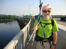
On the Cobble were these two guys, 
Mike and Tim. We chatted with them about the trail, as they were trail volunteers. They showed us a view that let us see Mt Greylock, a 3500 ft Mtn, the biggest since Virginia, that we would climb on the next day . Impressive!
We hiked on down toward the town and when we got down we ran into Mike and Tim again. They had a truck and said, " we'll be glad to give you a ride to resupply. So they drive us to a couple of convenience stores, as we sat in the truck bed, and we bought some basic stuff for the week, as resupplying after this point will be really difficult on our schedule.
Then they drive us to our Inn for the evening. What great guys! The Harbor House Inn was wonderful. Eva is the owner and is super nice.
We planned on sharing a room but she let us have two rooms for the same price, and we had a full breakfast, and got to stay in a beautiful home built in the 1700's. 
All cheaper than the motel the night before. What a nice person. I would like to go there again and take my Sweety.
She even drove us to dinner and she had a piano and Cisco got to play a bit.
Sometimes the hiker life is not so bad...The Harbor House Inn, Cheshire, MA

After dinner, to bed. No AC, but you don't need it here. Windows open and a cool pleasant sleep!
July 28 Mile 1564                 Road to the Cookie Lady's House!

Another crazy sleeping night. Cisco and I stayed in the shelter and during the night he had to wake me again. Said I was snoring so loud he was sure they heard me across the whole camping area. Weird.
Anyway, up and out by 7:30 and on to the Cookie lady's house. Near Becket MA, right off the trail is this wonderful old farm. When you go there the lady of the farm and Roy bring out fresh cookies to you and also sell you hard boiled eggs and soft drinks. You can also pick blueberries. Really nice people. We went there for
awhile and also sat with two other northbound thru hikers, Sunshine, from NC and Oliver Twist from London. Oliver wanted to know who lit the cauldron at the Olympics that started the night before. He hoped it was the Queen, but Roy didn't know.
After our break, we hiked on under threatening skies, then the bottom dropped out, and Cisco and I had the wettest hike since we were in PA. It poured for 4 hours and we had no relief or place to hide. No nice rock overhangs like in the REI commercial.
We were soaked on every square inch  down to our socks! All we could do was keep going forward till we reached our destination of Dalton MA. Cisco had been here before and knew that Tom Lavardie took in hikers at his house. We sloshed over to his house and met Tom. His house was full-with 17 hikers! The rain flushed us all out of the mountains it seemed. Don't know where they all fit. But he helped us find a motel and drove us there a few miles away. What a nice person to do this for people he doesn't know! On the way over to the motel we drove through the little town and passed a church with people going in for Saturday afternoon services.  It struck me, while these are all good people, I am sure, going to church, Tom is out here helping lots of people for no charge on this rainy afternoon. It reminded me of the parable of the Good Samaritan. God bless people like Tom. He makes the trail!
So we get a room ( pay waay too much for it ) do laundry, and all the other town things we are well used to by now, eat a big burger for dinner, watch the weather and go to bed!
Hope for a drier Sunday!
July 27 Mile 1552

Had a crazy night! Guess cause I was so tired. Went to sleep immediately, but then had a really goofy dream. Someone was telling me," your taxes are going up, your taxes are going up! You have to do something about it!" Anyway, evidently I starting yelling in my sleep and Cisco had to come over and tell me to stop. Weird!
Last time out I had major blisters on the first several weeks out and they were miserable. I figured this time with broken in boots, I would be ok-wrong. In the driving rain the other day my left foot was soaked and later I saw the beginnings of a blister.
Now this morning it turned into a full fledged monster, size of a quarter on the outside of my left foot above my heal. Ouch! So off we go with my new blister pinching me at every step. Luckily for me the Caretaker at the Upper Goose Pond Cabin was a nurse, so he helped me treat the blister so hiking would not be an excruciating experience!
Decided to do a shorter day after yesterday, only about nine miles.
Today I got to finish my lengthy American Presidential History lesson with Cisco. As I mentioned earlier, when we hike, the trail is sometimes conducive to talk.
We talked along time on Tuesday about the issues facing his generation as they try to find jobs and their place in the world. It was a very sobering discussion.
One of the things I like to talk about as we hike is history, particularly American history. For some reason history dates, facts, and places seem to stick in my head. While I can't remember half the stuff I am supposed to get at the grocery store, I know who the 17th President was.

So, I have this  useless talent of being able to name each US President in order and their years of service, plus at least one fact about them. So for 4 days I have given the lesson, we finally finished today with a look to the 2012 election. Whew! The only thing I was stuck on was a fact on Chester A Arthur... Yes, he was a President.
Got to the October Shelter pretty early and a good thing cause it was busy after we arrived. Met some new thru hikers . Met a southbounder who lives in  GA. Her name was Aqua, because she almost drowned trying to ford a Maine river. 
                                              Cisco in a trail of ferns.

Ate a dinner of turkey stuffing and salmon and to bed at sunset.
July 26 Mile 1543              Upper Goose Pond Cabin-Best hiker hostel ever!

Sleeping here at the North Wilcox Shelter was one of the worst sleeping  experiences ever. We couldn't get comfortable in our summer sleeping bags. They were like straight jackets and I couldn't seem to ever get to sleep. Maybe it was a hangover from the 5 hour energy drink? We got up as soon as the sun did, packed up and left to find water. Not good planning on our part. I learned last time out not to take my home kitchen faucet for granted.
When we finally found water up the trail the rain started again. We had been rained on each day, but one since we started. Didn't have that much rain in all of 2010 it seems. I told Cisco, I feel like we are in the "Hunger Games" and there is some Trailmaster out there watching and laughing at us as they send heat, humidity, treacherous rock uphills, downhills, mosquitos, gnats, a big blister, and never ending rain. "yeah, he said, but nobody is trying to kill us." Ok, but let's hope the hunters stay on their side of the white blaze.
Today my Sweety is sending us our winter sleeping bags. We are concerned about colder nights as we go as we gain elevation. So she sent the bags to the Tyringham MA, PO , a tiny place. We had to come off the trail about 1/2 mile to get there and any time you leave the trail it's a trial.
Nobody likes walking unnecessary miles. But this was important. So we come into town, a crossroads really, and unfortunately this is a place with no amenities for us- no stores, no restaurants. Just a PO and a sign.
The PO lady was very nice, luckily we got there before 12:30, cause that's when they close until 4:00!
Didn't know this was some part of Italy. As we unpack our shipping box out front of the P. O. people are driving by to pick up mail. One says to us seeing our distinctive dress, " be careful, a big storm is coming with tornado winds, i'm going home to tie down my furniture. " another lady walks by and says, " you'll be ok, you can hike up to the Upper Goose Creek Cabin , its only 7 miles away." thanks , we say.
So the sign: on the P.O. it said: "Hikers: Come across the street to the Cobble View B&B for snacks and cold drinks". Now that sounds refreshing and we know it's not free, and that's fine.
 So we go across the street to the B&B - a two story house - and we see this woman working in the yard. Cisco politely asks, "is this your place." She looks up  annoyed and says "yea".  Cisco then says "do you have any drinks or snacks, as advertised on the sign?"
Very annoyed she agrees she has a few things. Well, we say, we would like to buy them. " All I have is an orange and a Sprite, I'm out of snacks," ok we say, fine we'll take a couple of orange drinks- a buck each.  So, then I get bold, cause i really hate road walking and ask, " as it's so warm and its a ways back to the trail, do you know anyone who could give us a ride. I would be glad to compensate them." (  this is a common thing so close to the trail) She answered as  she looked down and shook her head , "there's nobody here who can do that and i don't have the time. " And it's then Cisco realizes this is the same woman who outside the PO a few minutes before told us "you can make the cabin 7 miles away." Now she could have used her entrepreneurial spirit and  said, "there is a storm coming, you can stay at my B&B, the charge is XXX, and you can continue on tomorrow." Instead,  it's more like, "I really don't care for you hikers (you can buy my soft drinks) now go on down the road through a storm to a cabin 7 miles away. " She had no interest in dealing with us hikers. So why have the sign welcoming us to your place!  We have seen so many wonderful people out here but, but the Cobble View B&B isn't among them. So we shook the dust off our feet to Tyringham and hiked out.The hike was grueling trying to get to the Upper Goose Pond Cabin from Tyringham.  Oh yeah, and did I mention bugs? Finally after a day of 16 miles, not all trail miles but road miles and side trail miles, we finally made it to the cabin.
 
I don't think I have ever been so exhausted in my life. Two years ago hiking 16 miles was tough, but not debilitating. This year, out of training, it was a killer! I knew that I could not keep up this pace. Even Cisco was pretty beat.
Well, we beat the storm anyway, and what did we behold but the Big Rock Candy Mountain of Hiker Heaven. This place was the best hiker rest stop of the entire AT!
And Free! All indoors, plenty of bunk space with mattresses, a lake, canoes, fresh coffee and PANCAKES!  in the morning provided by the caretaker. And you can stay as long as you want! What a country! Just as we got settled in the rain began to fall. We ate, chatted with the other very fortunate hikers and were very happy to go to bed. Best hiker place ever.
July 25 Mile 1529
Left Great Barrington, paying Pravin the motel manager$10 to give us a ride back to the trail. But at 4.5 miles away it was definitely worth it. Back hiking at 8:30 am, which is pretty good after a night in town. Hiked along the Housatonic River, again, and then went up and over East Mountain, never could figure out exactly where the mountain top was. Another low ridge we hike up to here in Mass and Ct, not really distinctive from anything we have seen from Ga to here. Mostly we are hiking through piedmont type forests and it looks alot like Fernbank Forest back home, but with more hills! But every now and then it turns into a hemlock grove and that is wonderful-lots of soft fir needles 
Beaver Pond

on the ground and a great aroma. Saw my first true beaver pond today. A very large pond, more like a lake actually, with a beaver lodge in the middle. And lots of beaver gnawed trees and stumps around. Today the weather was the best we have had since our return to the trail. Sunny, dry, and about 70 most of the day. But the Mosquitos and gnats are just awful. They dog our every step. We cannot even stop to rest. They are in your eyes and ears, biting whenever they can. We stopped for lunch at a very beautiful shelter-  Tom Leonard shelter, set in all of these huge rock ledges and with view of the valley below. The end of the day, with more ups and downs and rocks to climb, we were pushing hard to do 13.5 miles, which is alot for me so soon out. At lunch I drank a "5 hour energy drink" and it really seemed to motivate me. My hiking was much improved. By about 6:30 we were finally getting near the Mt Wilcox North Shelter where we were planning to spend our first night in one of their 3 sided shelters. As it was so hot, I had sucked my Platypus water system  dry and had about 2 cups of water in my water bottle. Same for Cisco. All shelters are built near water sources, but Mass is having a drought this year. We were greeted at the entrance to the shelter with a hand written sign:"no water". The little stream at the shelter dry as dirt. Maybe water at another location 1/2 mile away? We decided to stay put, ate tuna and pita bread and went to bed. Go find water tomorrow. :(
July 24 Mile 1516

Got up at sunrise and left Laurel Ridge campsite at 7:30am. It rained almost continuously throughout the night, but we were dry and cozy in our tents. Lightning and thunder.
Spent the morning hiking up Mt Everett and it was very tough. A 700 foot rise in .7 of a mile and here they have you go straight up!
Literally! And most of it is on solid rock, so we are now officially boulder hiking. Last time out a fellow hiker called it a "foot puzzle" where the heck do you put your feet? Imagine climbing Stone Mountain on the steep side. No switchbacks here. On top of Everett was an old fire tower foundation. I read that back in the 1940's, when the first thru hiker Earl Schafer went through, the mountains were loaded with manned fire towers, with people living in the tower or in a little house at the base.
They would invite him in and serve him dinner. No dinner here now.
We could see a storm off in the distance and figured the nice breeze was blowing up a storm and didn't want to be the highest thing when the lightning started. So off we went to get down the mountain. Things were fine until halfway down the sky opened up and the rain poured. We were in the steep downward rocks at the time trying to keep our balance and Cisco yelled at me "don't run!" But I was slipping on the rocks and couldn't help myself. Luckily no harm done . We got our pack covers on and slogged through the rain . You have to protect your pack. Did not wear our rain jackets. Too warm for that, just got wet. Once the rain stopped we started to dry out, making it down to the lowlands and Route 7. On the way we passed an historical marker for Shays Rebellion 1787. I'll let you google it. Lots of history on the trail. This is definitely a walking tour of America.
It was windy on top so we got all our wet things out to dry from the night before. Our gear dries very quickly, which is very good thing.  
Spent the night in town- Great Barrington Mass. Nice town and a good day's hike.
                                           On the Mountain top!

                                                     Shay's Rebellion!